SEA- HAWKS… I mean, More Mapping
Plan of the Day
- While the OG plan of the day was to watch the Seahawks redeem the worst decision in football… I really wanted to complete the draft maps of the significantly spatially autocorrelated contaminant classes so I could start fresh on some of the other tasks for the week on Monday.

Projects Touched Today
- Mussel Biomarkers
Progress Notes
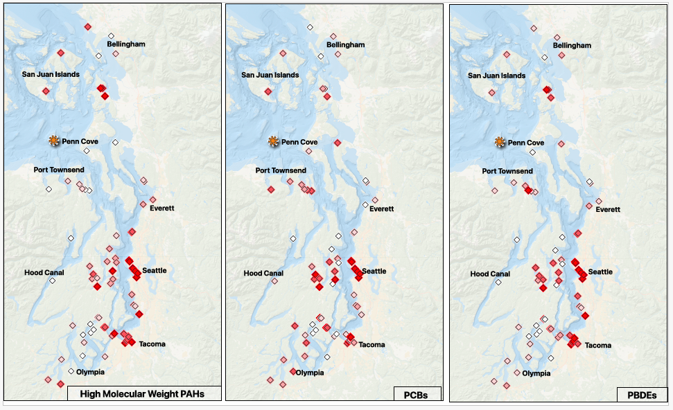
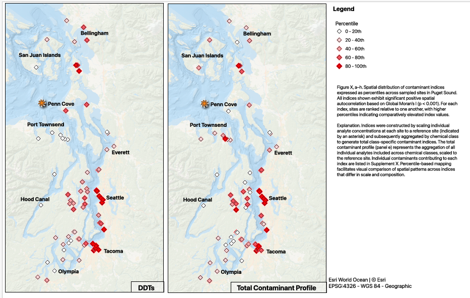
Started off today reviewing what I knocked out yesterday, and picked back up on mapping the contaminant indices.
Splitting the significant indices into percentiles and detected/ not detected, that makes my layout simpler - I am going to put a grid together for the percentile maps; one shared legend. The top row will be (L-R) pah, pcb, pbde; the bottom row will be (L-R) ddt, total contaminants, legend.
Set my print layout to ANSI B - Landscape; 431.8mm x 279.4mm to make sure I can get 3 across without crowding.
The maps have the same exact setup, only the data varies, so this feels like it should be a clean way to compare the information.
Can’t forget to add the map attribution: Basemap: Esri World Ocean | © Esri, and the projection: base- EPSG: 3857, points- EPSG:4326 - WGS 84 - Geographic
NOTE: When I return to the sampling site and P450 maps- they need to match the extent, scale, and labeling of these maps.
Fix the city/ location labels
Everett is misspelled
Olympia may be misplaced
Add Port Angeles or Port Townsend, lots of sites= label
Consider adding waterway labels, like Commencement Bay, Elliott Bay, greater Salish Sea and/ or Puget Sound
Back to the contaminant maps
There is an asterisk indicating the reference site - orange and just slightly larger than the map points; don’t forget to add this in the caption
This is a bit dramatic on the page - adjust when refining the maps
- I am so excited to have finally gotten much closer to aligning the figures with the story in the manuscript draft - since the whole thing is on the shorter side, the figures really have to deliver. There is definite room for improvement; small cleanups on things like aligning frames, text styles, naming convention (I don’t think I should pluralize the contaminant abbreviations), and larger refinements for clarity and overall message delivery will be tackled after committee feedback.
Products & Word Count
Viz made: 5 maps + captioning (357 words)
Today’s total: 357 words
Monthly total to date: 2,075 words
Annual total to date: 14,953 words
Tomorrow’s Plan
Reminder to committee to review my MS proposal so I can get it submitted
MS proposal must be submitted and signed off NLT 2/20/26
Schedule a meeting for end of February, early March to discuss PhD proposal and manuscript (full committee will receive NLT MS feedback/ submission is completed)
Spend some time reviewing the status of my current projects
I have spent so much time in the QGIS rabbit hole that I need to refresh myself on where everything else stands
Map plan for the week based on that review (including blocks for non-dissertation projects that have also lagged)
Put up outline of 1v1 agenda/ statuses to be completed in advance of my meeting with Steven on 2/11